
Sonntag, 13. September 2015
150912 Sellaronde
neill, 22:35h
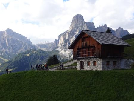
Once again down in to town and then up in to the mountains with a lift. At the top we were once again presented with truly amazing mountain scenery. We trailed across to a pass and then a long long downhill all on trails and tracks.
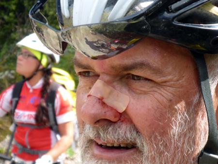
At the bottom we took two cable cars back up to a summit. From the top there was an extra bike park trail so we followed that all the way down to the road. I was too slow over a jump so nosedived and landed on my head. Broke my helmet.
Back up to another pass and then more trailing. Mud paths, ski slopes and rocky tracks. Eventually things got serious and we cycled back up to a mountain hut at the top of the pass for a fantastic lunch.
From the pass it was another long series of downhills and then uphill past a monstrous landslide. Finally we took a last lift to the top of the pass and then a stunning trail almost all the way back down.
Finished with coffee in the village.
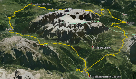
54km with 3075 meters of climbing - but most of that with lifts.
7km and 1800 meters of climbing was with lifts.
Track is at
http://www.gpsies.com/map.do?fileId=yqegbezoplkwhsyt
My pictures are at https://goo.gl/photos/odTbfVPddLC5jhZL8
Hubert's pictures at https://goo.gl/q82wN8
Caro's pictures at https://drive.google.com/folderview?id=0B8GQ5A_ddT-wWTBORlZyWXlMdFk&usp=sharing&tid=0B8GQ5A_ddT-wZ25BZ1g3ZmdlUW8
Stefanos's pictures at https://drive.google.com/folderview?id=0B8GQ5A_ddT-wT1o1REVkMWd5Sk0&usp=sharing&tid=0B8GQ5A_ddT-wZ25BZ1g3ZmdlUW8
Inge's pictures are at https://picasaweb.google.com/SpyderwomanTV/Wolkenstein3Tag120915?authkey=Gv1sRgCJ6u_MiEjYzEag&feat=email
At the bottom we took two cable cars back up to a summit. From the top there was an extra bike park trail so we followed that all the way down to the road. I was too slow over a jump so nosedived and landed on my head. Broke my helmet.
Back up to another pass and then more trailing. Mud paths, ski slopes and rocky tracks. Eventually things got serious and we cycled back up to a mountain hut at the top of the pass for a fantastic lunch.
From the pass it was another long series of downhills and then uphill past a monstrous landslide. Finally we took a last lift to the top of the pass and then a stunning trail almost all the way back down.
Finished with coffee in the village.
54km with 3075 meters of climbing - but most of that with lifts.
7km and 1800 meters of climbing was with lifts.
Track is at
http://www.gpsies.com/map.do?fileId=yqegbezoplkwhsyt
My pictures are at https://goo.gl/photos/odTbfVPddLC5jhZL8
Hubert's pictures at https://goo.gl/q82wN8
Caro's pictures at https://drive.google.com/folderview?id=0B8GQ5A_ddT-wWTBORlZyWXlMdFk&usp=sharing&tid=0B8GQ5A_ddT-wZ25BZ1g3ZmdlUW8
Stefanos's pictures at https://drive.google.com/folderview?id=0B8GQ5A_ddT-wT1o1REVkMWd5Sk0&usp=sharing&tid=0B8GQ5A_ddT-wZ25BZ1g3ZmdlUW8
Inge's pictures are at https://picasaweb.google.com/SpyderwomanTV/Wolkenstein3Tag120915?authkey=Gv1sRgCJ6u_MiEjYzEag&feat=email
... comment