
... newer stories
Donnerstag, 12. Februar 2015
150212 Gaishorn
neill, 16:37h
The Gaishorn summit is 2247 meters above sea level and a classic skitour in neighbouring Tannheimertal. A picture is at http://de.wikipedia.org/wiki/Gaishorn_(Allg%C3%A4uer_Alpen)#mediaviewer/File:Gaishorn_am_Gaishorn.JPG
A picture from Wikipedia showing the final part of our route. („Gaishorn Nordflanke02“ von Kauk0r - Eigenes Werk. Lizenziert unter CC BY-SA 3.0 über Wikimedia Commons).
Took the morning off today. Up at 05:00, Breakfast at 05:30, on our way to Austria at 06:10 and on the skis at 06:44.
As we left it was -7°C and you could just make out the difference between sky and mountains in the early morning light.
It took us four hours to walk with our skis up to the summit of the Gaishorn. A lot of that was spent on the steep 400 meter ascent to the Gaiseck. Here we had to repeatedly do kick turns which slowly drained us of energy. We are both fit but by the time we reached the Gaiseck we had pulses of well over 140 beats per minute.

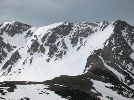
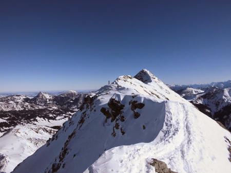
At the Gaiseck we left our skis and walked along the snow covered ridge to the Gaishorn. Finally we could enjoy the sun as until this point we had been in the shadow on the north flank of the mountain. The picture at http://de.wikipedia.org/wiki/Gaishorn_(Allg%C3%A4uer_Alpen)#mediaviewer/File:Gaishorn_Nordflanke02.JPG shows the route well - firstly up the steep snow field on the right and then along the ridge to the summit on the left.
The total climb was 1100 meters.
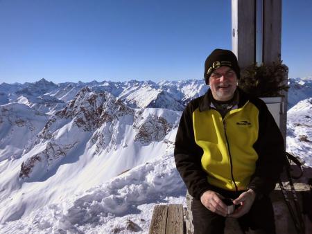
A bite to eat, a flask of hot tea and many photos kept us occupied at the summit while enjoying the amazing views in every direction.
We then walked back to the Gaiseck and enjoyed a super steep run through the fresh snow back down in to the valley.
1150 meters of climbing. Route is at http://www.gpsies.com/map.do?fileId=nutxmdtazgdhqtif
More photos at https://plus.google.com/u/0/photos/103827427036815679772/albums/6097506762533868817
#mediaviewer/File:Gaishorn_am_Gaishorn.JPG)
A picture from Wikipedia showing the final part of our route. („Gaishorn Nordflanke02“ von Kauk0r - Eigenes Werk. Lizenziert unter CC BY-SA 3.0 über Wikimedia Commons).
Took the morning off today. Up at 05:00, Breakfast at 05:30, on our way to Austria at 06:10 and on the skis at 06:44.
As we left it was -7°C and you could just make out the difference between sky and mountains in the early morning light.
It took us four hours to walk with our skis up to the summit of the Gaishorn. A lot of that was spent on the steep 400 meter ascent to the Gaiseck. Here we had to repeatedly do kick turns which slowly drained us of energy. We are both fit but by the time we reached the Gaiseck we had pulses of well over 140 beats per minute.
At the Gaiseck we left our skis and walked along the snow covered ridge to the Gaishorn. Finally we could enjoy the sun as until this point we had been in the shadow on the north flank of the mountain. The picture at http://de.wikipedia.org/wiki/Gaishorn_(Allg%C3%A4uer_Alpen)#mediaviewer/File:Gaishorn_Nordflanke02.JPG shows the route well - firstly up the steep snow field on the right and then along the ridge to the summit on the left.
#mediaviewer/File:Gaishorn_Nordflanke02.JPG)
The total climb was 1100 meters.
A bite to eat, a flask of hot tea and many photos kept us occupied at the summit while enjoying the amazing views in every direction.
We then walked back to the Gaiseck and enjoyed a super steep run through the fresh snow back down in to the valley.
1150 meters of climbing. Route is at http://www.gpsies.com/map.do?fileId=nutxmdtazgdhqtif
More photos at https://plus.google.com/u/0/photos/103827427036815679772/albums/6097506762533868817
... link (0 Kommentare) ... comment
... older stories