
... newer stories
Montag, 9. September 2013
130908 Coffee in Cortina
neill, 23:14h
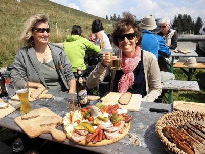
The fourth day in Cortina and only five of us did a quick "road tour" up the hill for a coffee.
11 kms and 430 meters of climbing. Track is at
http://www.gpsies.com/map.do?fileId=xgzohscueqmupxsd
My pictures are at https://plus.google.com/photos/103827427036815679772/albums/5921707781848663521?banner=pwa&authkey=CPumgJP8gZGkqwE
Jon's pictures at https://plus.google.com/u/0/photos/100547066824249637955/albums/5921540097943142497
... link (0 Kommentare) ... comment
Samstag, 7. September 2013
130907 Val de Gotres
neill, 19:40h
After the huge tour yesterday, and after Jon had rebuilt my bike at the local bike handler, we did a "nice gentle" Dolomite tour through the Val de Gotres.
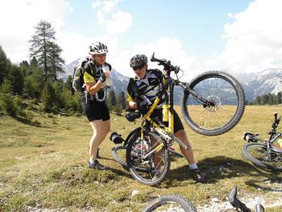
Only 33 kms and only 860 meters of climbing but what a great day. The perfect follow on to yesterday.
Track is at http://www.gpsies.com/map.do?fileId=jfmgpmewfmiudaas
My pictures are at https://plus.google.com/photos/103827427036815679772/albums/5921705411362024705?banner=pwa&authkey=CNaKwIK-idTsPA
Jon's pictures are at https://plus.google.com/u/0/photos/100547066824249637955/albums/5920913105040886065
... link (0 Kommentare) ... comment
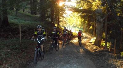
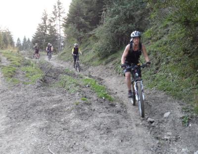
130906 Round the Tofana
neill, 19:35h
Wow!
It took 11 hours but we did it. Once round the Tofana Massive in the Dolomites. Stunning scenery, incredibly rocky tracks and some amazing single rails to finish with.
Broke my bike but I survived in one piece.
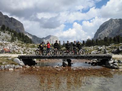
"Only" 55kms and we used the cable car for the first 500 meters of climb but still a really hard day.
Track at http://www.gpsies.com/map.do?fileId=wvjzykkvnljdlbbc
My pictures are at https://plus.google.com/photos/103827427036815679772/albums/5921701433081116897?banner=pwa&authkey=CPzD-YXqktCoQQ
Jon's pictures are at https://plus.google.com/photos/100547066824249637955/albums/5920615267498635201
It took 11 hours but we did it. Once round the Tofana Massive in the Dolomites. Stunning scenery, incredibly rocky tracks and some amazing single rails to finish with.
Broke my bike but I survived in one piece.
"Only" 55kms and we used the cable car for the first 500 meters of climb but still a really hard day.
Track at http://www.gpsies.com/map.do?fileId=wvjzykkvnljdlbbc
My pictures are at https://plus.google.com/photos/103827427036815679772/albums/5921701433081116897?banner=pwa&authkey=CPzD-YXqktCoQQ
Jon's pictures are at https://plus.google.com/photos/100547066824249637955/albums/5920615267498635201
... link (0 Kommentare) ... comment
Donnerstag, 5. September 2013
130905 Drei Zinnen
neill, 20:09h
First day in Cortina. we stopped on the way to the hotel and cycled up to the foot of the "Drei Zinnen".
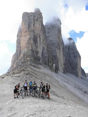
Once we were back at the car I had to drive car and trailer to Cortina while the rest rode.
20kms and 870 meters of climbing
Track at http://www.gpsies.com/map.do?fileId=dffnwhrzxanhjvqj
My photos are at https://plus.google.com/photos/103827427036815679772/albums/5921697511266403633?banner=pwa&authkey=CO_986yx6ebeWQ
Jon's photos are at https://plus.google.com/photos/100547066824249637955/albums/5920173938618210641
Max was out with the heros in Group 1. His reports and links to his pictures are at http://maxhogarth.blogspot.de/2013_09_01_archive.html
... link (0 Kommentare) ... comment
Dienstag, 3. September 2013
130903 Grüntensee
neill, 22:15h
The usual four of us (Heidi, Moni, Jon and I) doing the normal training run on a Tuesday night.
Once round the lake and then home via Maria Rain.
We needed to save our energy for the coming weekend in Italy :-)
27 kms and 300 meters of climbing. Track at http://www.gpsies.com/map.do?fileId=zevcsammdqcdqpao
Once round the lake and then home via Maria Rain.
We needed to save our energy for the coming weekend in Italy :-)
27 kms and 300 meters of climbing. Track at http://www.gpsies.com/map.do?fileId=zevcsammdqcdqpao
... link (0 Kommentare) ... comment
Samstag, 31. August 2013
130831 Roßbergalpe
neill, 22:46h
Dorothee was visiting from Milan so Heidi, Hermann, Alison and I took her to the Roßbergalpe for lunch.
Pictures at https://plus.google.com/u/0/photos/103827427036815679772/albums/5853746597235744401
Pictures at https://plus.google.com/u/0/photos/103827427036815679772/albums/5853746597235744401
... link (0 Kommentare) ... comment
130829 Beichelstein
neill, 22:13h
The evenings are getting shorter so we need to stay a little closer to home or be sure we do the dark part of the tour on good tracks.
Tonight we chose the second option and just got down off the Beichelstein before dark.
Great picture from Jon
My (three) photos at https://plus.google.com/photos/103827427036815679772/albums/5903015570987104113?banner=pwa
32 kms and 570 meters of climbing. Track at
http://www.gpsies.com/map.do?fileId=xgpjyczgwbqluyzq
Jon's photos at https://plus.google.com/photos/100547066824249637955/albums/5865862959006086625/5917865466616081458?pid=5917865466616081458&oid=100547066824249637955
... link (0 Kommentare) ... comment
Freitag, 23. August 2013
130822 Bayerstetter Köpfel
neill, 09:21h
Thursday evening and seven of us were out with our mountain bikes.
After climbing up to the Bayerstetter Köpfel and then trailing back down, we enjoyed a variety of paths near the Grüntensee.
20kms and 500 meters of climb
Track is at http://www.gpsies.com/map.do?fileId=lqlwolvukczzkcrf

Photos at https://plus.google.com/photos/103827427036815679772/albums/5903015570987104113?banner=pwa
After climbing up to the Bayerstetter Köpfel and then trailing back down, we enjoyed a variety of paths near the Grüntensee.
20kms and 500 meters of climb
Track is at http://www.gpsies.com/map.do?fileId=lqlwolvukczzkcrf
Photos at https://plus.google.com/photos/103827427036815679772/albums/5903015570987104113?banner=pwa
... link (0 Kommentare) ... comment
Donnerstag, 22. August 2013
130820 Bodelsberg
neill, 09:33h
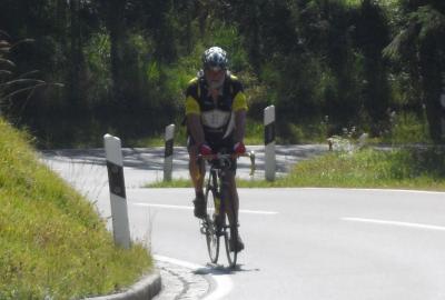
Three of us out on our race bikes keeping away from the big black clouds in the mountains.
We actually planned a completely different route but Jon and I missed the turning in Gschwend as we were chasing a car.
39km and 519 meters of climbing.
Track is at http://www.gpsies.com/map.do?fileId=fzafhaxudquroycm
We actually planned a completely different route but Jon and I missed the turning in Gschwend as we were chasing a car.
39km and 519 meters of climbing.
Track is at http://www.gpsies.com/map.do?fileId=fzafhaxudquroycm
... link (0 Kommentare) ... comment
Montag, 19. August 2013
130818 Königsstrasse and Jochpass
neill, 00:37h
After over a week of lounging around on a boat it probably was not the best idea to go and do a long race bike tour with the super fit Jon. But that is what I did.
My GPS batteries ran out during the trip but Jon has posted the route to GPSies http://www.gpsies.com/map.do?fileId=sjpffwvnbevobmgd (58kms with 920 meters of climbing!)
Max had my camera on his weekend tour to Italy so I have very few pictures. I did however take this panorama at the top of the Jochpass.

The original is at https://plus.google.com/photos/103827427036815679772/albums/5903015570987104113/5913700661952478722?banner=pwa&pid=5913700661952478722&oid=103827427036815679772
Once we got back I had to drive to Italy to pick up Max and Nico who had spent the weekend cycling from Nesselwang to St. Leonhard. At least they bought me an ice.

Max's description of his trip to Italy is here http://maxhogarth.blogspot.de/2013/08/timmeljoch-day-1-familiar-territory.html?spref=fb
My GPS batteries ran out during the trip but Jon has posted the route to GPSies http://www.gpsies.com/map.do?fileId=sjpffwvnbevobmgd (58kms with 920 meters of climbing!)
Max had my camera on his weekend tour to Italy so I have very few pictures. I did however take this panorama at the top of the Jochpass.
The original is at https://plus.google.com/photos/103827427036815679772/albums/5903015570987104113/5913700661952478722?banner=pwa&pid=5913700661952478722&oid=103827427036815679772
Once we got back I had to drive to Italy to pick up Max and Nico who had spent the weekend cycling from Nesselwang to St. Leonhard. At least they bought me an ice.
Max's description of his trip to Italy is here http://maxhogarth.blogspot.de/2013/08/timmeljoch-day-1-familiar-territory.html?spref=fb
... link (0 Kommentare) ... comment
Donnerstag, 8. August 2013
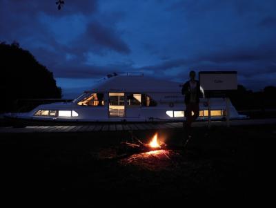
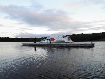
130808 Boating in Fermanagh
neill, 13:02h
The whole family spent a week boating on the Erne and Shannon in Ireland.
We started in Northern Ireland and then passed along the canal in to Eire. Later we returned to the starting point in County Fermanagh.
My pictures are here https://plus.google.com/photos/103827427036815679772/albums/5912802555955779201?banner=pwa&authkey=CPrW1OvF8-3SowE
The track we followed is at http://www.gpsies.com/map.do?fileId=esviayrvlmrukinm
... link (0 Kommentare) ... comment
Dienstag, 6. August 2013
130806 In the rain
neill, 23:12h
The weather forecast was very bad but we decided to go race biking anyway. Hadn't got 3 kms when it started raining so we went to our house and enjoyed a few beers on the terrace.
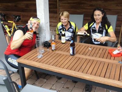
The boys had also invited their friends round so it turned in to a party.
The following photo is of some really strange hail
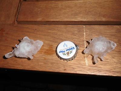
Photos at https://plus.google.com/photos/103827427036815679772/albums/5853746597235744401?banner=pwa&partnerid=pwrd1
The boys had also invited their friends round so it turned in to a party.
The following photo is of some really strange hail
Photos at https://plus.google.com/photos/103827427036815679772/albums/5853746597235744401?banner=pwa&partnerid=pwrd1
... link (0 Kommentare) ... comment
130805 Roßbergalm
neill, 23:10h
Cycled up to the Roßbergalm this evening with Barbara (the company's tax advisor).
We just managed to get back down before darkness fell.
Video taken on the way at http://www.youtube.com/watch?v=EP3xltvehRw&feature=youtu.be
We just managed to get back down before darkness fell.
Video taken on the way at http://www.youtube.com/watch?v=EP3xltvehRw&feature=youtu.be
... link (0 Kommentare) ... comment
Sonntag, 4. August 2013
130804 Viehweidefest & Schwaltenweiher
neill, 19:24h
Yesterday was the 8th Viehweidefest at French/Klotz's so a late night in bed. After helping to tidy up I cycled to the Schwaltenweiher to watch the beach volleyball competition. Just got back before the rain storm.
Viehweidefest photos at https://plus.google.com/photos/103827427036815679772/albums/5908286638809907441?banner=pwa
2 vidoes of "Noyes" and their fans.
http://www.youtube.com/watch?v=4lxWi8tkU8s
and
http://www.youtube.com/watch?v=RUokhfb2ohI
Track to Schwaltenweiher at http://www.gpsies.com/map.do?fileId=pagwttsbheaxtktz
... link (0 Kommentare) ... comment
Freitag, 2. August 2013
130801 Rehbach (Vilstal backwards)
neill, 21:10h
Met on Thursday evening for one of our "standard tours" and then decided to do it the other way round. Amazing the things you see when you ride the "other way round".
As requested by Wera, we also added in a small diversion on the way to Wertach.
43 kms and nearly 700 meters of climbing
http://www.gpsies.com/map.do?fileId=lmnzjzbefwhewlpw
Pictures at https://plus.google.com/photos/103827427036815679772/albums/5903015570987104113?banner=pwa
As requested by Wera, we also added in a small diversion on the way to Wertach.
43 kms and nearly 700 meters of climbing
http://www.gpsies.com/map.do?fileId=lmnzjzbefwhewlpw
Pictures at https://plus.google.com/photos/103827427036815679772/albums/5903015570987104113?banner=pwa
... link (0 Kommentare) ... comment
Mittwoch, 31. Juli 2013
130730 Geocaching in Wald
neill, 09:17h
This evening Jon suggested a bit of "race bike geocaching".

We cycled to Wald and then did four geocaches.
https://www.geocaching.com/seek/cache_details.aspx?guid=b8c46363-557d-485c-9c44-9f0cb59b3f3f
https://www.geocaching.com/seek/cache_details.aspx?guid=3b7f9ba3-4ba7-488c-aeb1-9f73cc2f23ce
https://www.geocaching.com/seek/cache_details.aspx?guid=78d0443e-bcef-47e3-a3c1-cbfa0e27d027
https://www.geocaching.com/seek/cache_details.aspx?guid=a8d1e5a3-b968-47f6-93fd-aa3a0a94e632
Couldn't find the first one but the other three we found (Jon found two and a local showed us the fourth). We also got a guided tour of the local museum.
Cycled back via Lengenwang and Seeg to avoid finishing the tour with the "Ruckholzer Steig".
39kms with 500 meters of climbing
http://www.gpsies.com/map.do?fileId=dacpdazcyxruggxy
Jon's photos are at https://plus.google.com/photos/100547066824249637955/albums/5865862959006086625
... link (0 Kommentare) ... comment
Sonntag, 28. Juli 2013
130728 Allatsee
neill, 21:20h
Today we had temperatures in the upper 30s so five of us cycled to the Allatsee for a swim. Afterwards we went for an ice in Nesselwang. It is a tough life.
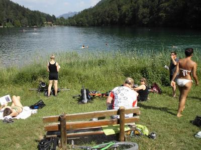
34 kms but only 300 meters of climbing - enough in these temperatures.
Track at http://www.gpsies.com/map.do?fileId=jjtvblvppkcpnphy
Photos at https://plus.google.com/photos/103827427036815679772/albums/5887203753058455121/5905722997877746834?banner=pwa&pid=5905722997877746834&oid=103827427036815679772
... link (0 Kommentare) ... comment
... older stories