
... newer stories
Mittwoch, 3. September 2014
140902 Moorgang
neill, 00:10h
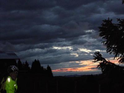
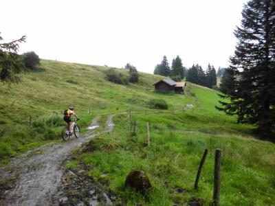
Another rainy Tuesday and once again it was just Heidi and I. I had been working outside all afternoon and didn't feel like a trip up in to the mountains so we went across to the Moorgang and then up through Mittelberg on to the Ellegg. It only rained a bit and was not so cold.
Didn't take my GPS but I guess it was about 25 kilometers.
Didn't take my GPS but I guess it was about 25 kilometers.
... link (0 Kommentare) ... comment
Samstag, 30. August 2014
140830 Karwendelrunde
neill, 23:26h
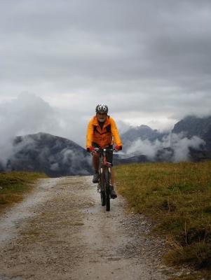
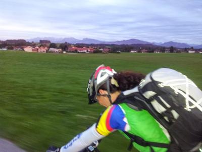
Despite the showers and low cloud we had a fantastic day doing the Karwendelrunde. The 2000 meters of climbing was challenging for me but the scenery was stunning. Almost the entire route was on forest tracks but we found a few trails to add to the fun.
Until the Karwendelhütte we only met two other cyclists and they were in the process of abandoning their planned tour. Once we saw four hillwalkers far off on the other side of the valley. Obviously the rain kept every one at home. It was amazing having so much mountain just for us.
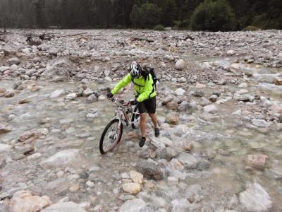
During the worst rain of the trip we had to ford a river. Heidi fell in as we were jumping from stone to stone and did the rest of the tour in soaking shoes.
The day before this ride I was in Friedrichshafen with Jon at the big bike show. The amazing thing there was almost everything was about "Image". There were bikes for eight thousand Euros, cool looking clothes and accesories of every kind but it all seemed to be about "buy our stuff and show people what a great biker you are".Today was very different. Just the two of us, our "normal" bikes, the mountains and the rain. But today was what biking is really about - getting out there and enjoying yourself even without people applauding your great taste in clothing or your expensive bike. I still believe that the most important things are your legs for getting you uphill and your head for getting you back down.
75km and over 2000 meters of climbing.
http://www.gpsies.com/map.do?fileId=czrpwdszgdnwmlrn
Actually the distance was nearer to 77km. The distances that I write in this blog are those shown at gpsies.com but these are those measured on a flat map. The actual distance covered needs to take account of the ups and downs. But, at the end of the day, who cares about 2km.
Photos at https://plus.google.com/u/0/photos/103827427036815679772/albums/6050786238514201409?authkey=CM6y9qnHhfj9mAE
Until the Karwendelhütte we only met two other cyclists and they were in the process of abandoning their planned tour. Once we saw four hillwalkers far off on the other side of the valley. Obviously the rain kept every one at home. It was amazing having so much mountain just for us.
During the worst rain of the trip we had to ford a river. Heidi fell in as we were jumping from stone to stone and did the rest of the tour in soaking shoes.
The day before this ride I was in Friedrichshafen with Jon at the big bike show. The amazing thing there was almost everything was about "Image". There were bikes for eight thousand Euros, cool looking clothes and accesories of every kind but it all seemed to be about "buy our stuff and show people what a great biker you are".Today was very different. Just the two of us, our "normal" bikes, the mountains and the rain. But today was what biking is really about - getting out there and enjoying yourself even without people applauding your great taste in clothing or your expensive bike. I still believe that the most important things are your legs for getting you uphill and your head for getting you back down.
75km and over 2000 meters of climbing.
http://www.gpsies.com/map.do?fileId=czrpwdszgdnwmlrn
Actually the distance was nearer to 77km. The distances that I write in this blog are those shown at gpsies.com but these are those measured on a flat map. The actual distance covered needs to take account of the ups and downs. But, at the end of the day, who cares about 2km.
Photos at https://plus.google.com/u/0/photos/103827427036815679772/albums/6050786238514201409?authkey=CM6y9qnHhfj9mAE
... link (0 Kommentare) ... comment
Freitag, 29. August 2014
140828 Buronhütte
neill, 08:47h
Thursday and it did not rain all day. A bit of a surprise this summer. Eight of us were out in Group 2.
26km and 639 meters of climbing
Track at http://www.gpsies.com/map.do?fileId=otvxerakxadnanpj
Pictures at https://plus.google.com/u/0/photos/103827427036815679772/albums/6050786238514201409?authkey=CM6y9qnHhfj9mAE
26km and 639 meters of climbing
Track at http://www.gpsies.com/map.do?fileId=otvxerakxadnanpj
Pictures at https://plus.google.com/u/0/photos/103827427036815679772/albums/6050786238514201409?authkey=CM6y9qnHhfj9mAE
... link (0 Kommentare) ... comment
Mittwoch, 27. August 2014
140826 Herzer Hütte
neill, 09:09h
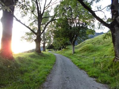
It was too wet for Jon and Moni so Heidi and I took our mountain bikes and cycled up to the Herzer Hütte. Despite the bad weather all day, it only rained for a few minutes while we were in a wood so we reached the hut still dry. It was also still light so we cycled back the long way via the Buron Hütte.
At one point a gust of wind nearly blew me off my bike but in the shade of the trees we didn't really notice the storm.
22km and 770 meters of climbing. Track is at
http://www.gpsies.com/map.do?fileId=oabcjuokvrgagsxo
Pictures at https://plus.google.com/u/0/photos/103827427036815679772/albums/6050786238514201409?authkey=CM6y9qnHhfj9mAE
... link (0 Kommentare) ... comment
Sonntag, 24. August 2014
140824 Alte Joch Pass
neill, 23:51h
An amazing Sunday Evening tour. Both Heidi and I needed lots of zone 2 and 3 to finish our training weeks so we cycled up over the two passes on the Königsstrasse and then back up the Alte Jochpass - amazing that something so steep is possible with race bikes.
Still needed more so cycled over the pass to Schattwald and then back to Unterjoch and home.
Great evening with great weather and great views.
63km with 1050 meters of climbing!
Track at http://www.gpsies.com/map.do?fileId=uyocxwlkhskeziis
Still needed more so cycled over the pass to Schattwald and then back to Unterjoch and home.
Great evening with great weather and great views.
63km with 1050 meters of climbing!
Track at http://www.gpsies.com/map.do?fileId=uyocxwlkhskeziis
... link (0 Kommentare) ... comment
Samstag, 23. August 2014
140821 Stubental
neill, 19:32h
Thursday evening tour. Everyone thought it was cold and would be dark soon so we only did a quick tour round the Edelsberg. I would have enjoyed somethimg a little more challenging but "the group" wanted something relaxing.

25km and 650 meters of climbing
Track at http://www.gpsies.com/map.do?fileId=opgqgskxlbhfimlj
25km and 650 meters of climbing
Track at http://www.gpsies.com/map.do?fileId=opgqgskxlbhfimlj
... link (0 Kommentare) ... comment
Mittwoch, 20. August 2014
140820 Füssen
neill, 21:59h
Just Heidi and I (Jon was ill and Moni tired) out on our race bikes.
46km and 450 meters of climbing
Track at http://www.gpsies.com/map.do?fileId=wepdjrdzwftrrfkp
46km and 450 meters of climbing
Track at http://www.gpsies.com/map.do?fileId=wepdjrdzwftrrfkp
... link (0 Kommentare) ... comment
Sonntag, 17. August 2014
140817 Tannheimertal
neill, 17:52h
A sunny Sunday and needed to get my zones finished for the week. Alison came along so went on my mountain bike and took things gently. By the time we reached Nesselwang I still did not have zone 2 finished so rode up towards Maria Trost until I had the 100%.
3 hrs 47 minutes moving time!
Pictures at https://plus.google.com/u/0/photos/103827427036815679772/albums/6030336146678088705
53 km and 800 meters of climbing.
Track at http://www.gpsies.com/map.do?fileId=xsenkqwntetukrqt
3 hrs 47 minutes moving time!
Pictures at https://plus.google.com/u/0/photos/103827427036815679772/albums/6030336146678088705
53 km and 800 meters of climbing.
Track at http://www.gpsies.com/map.do?fileId=xsenkqwntetukrqt
... link (0 Kommentare) ... comment
140816 Rafting
neill, 17:49h
Rafting on the Iller with colleagues and their families.
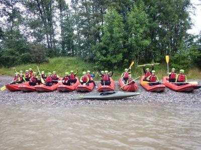
Some pictures at https://plus.google.com/u/0/photos/103827427036815679772/albums/6019625995923164481?authkey=CIqchoCt_NH-lAE
Some pictures at https://plus.google.com/u/0/photos/103827427036815679772/albums/6019625995923164481?authkey=CIqchoCt_NH-lAE
... link (0 Kommentare) ... comment
Dienstag, 12. August 2014
140812 Wildpoldsried
neill, 23:48h
Out with Jon and Heidi on the race bikes.
62 km and 680 meters of climbing.
Track is at http://www.gpsies.com/map.do?fileId=ftkkvljlfdkxcvxb It is Jon's track because my GPS is still on the way to Venice with Max ( http://maxhogarth.blogspot.de/2014/08/day-1-nesselwang-seefeld-unfinished.html ).
62 km and 680 meters of climbing.
Track is at http://www.gpsies.com/map.do?fileId=ftkkvljlfdkxcvxb It is Jon's track because my GPS is still on the way to Venice with Max ( http://maxhogarth.blogspot.de/2014/08/day-1-nesselwang-seefeld-unfinished.html ).
... link (0 Kommentare) ... comment
Sonntag, 10. August 2014
140808 Jungholz
neill, 18:39h
A quick race bike tour to top up my zones for this week.
No GPS as Max has mine on his trip to Venice.
32km.
No GPS as Max has mine on his trip to Venice.
32km.
... link (0 Kommentare) ... comment
140810 Kenzenhütte
neill, 18:34h
A sunday tour in an area unknown to most of us. I seem to remember that four of us were here about 10 years ago but took a different route.
Cycled up to the Kenzenhütte for lunch then down and back up to the Buchenberger Alp for coffee and then back down again and back to Nesselwang for ice cream.
28km and 770 meters of climbing
Jons track is at http://www.gpsies.com/map.do?fileId=gjywafyothzuayuz My GPS is on the way to Italy with Max
My pictures at https://plus.google.com/u/0/photos/103827427036815679772/albums/6030336146678088705
... link (0 Kommentare) ... comment
Freitag, 8. August 2014
140807 Eisenberg
neill, 00:47h
10 of us out on mountainbikes and following trails selected by Wera again. Great route.
31km and 680 meters of climbing
Track at http://www.gpsies.com/map.do?fileId=qsmbfjfyndrkvfol
31km and 680 meters of climbing
Track at http://www.gpsies.com/map.do?fileId=qsmbfjfyndrkvfol
... link (0 Kommentare) ... comment
Mittwoch, 6. August 2014
140805 Tannheimertal
neill, 11:31h
The "standard" ride through Tannheimertal. With Moni and Heidi. It didn't rain until we got back to Nesselwang.
52kms and 590 meters of climbing
Track at http://www.gpsies.com/map.do?fileId=klsojlkpbucpnqgy
52kms and 590 meters of climbing
Track at http://www.gpsies.com/map.do?fileId=klsojlkpbucpnqgy
... link (0 Kommentare) ... comment
Sonntag, 3. August 2014
140803 Mittelberg
neill, 22:20h
Heidi and I both needed training time to complete our training schedules this week so we spent two hours riding up and down hills.
34kms and 660 meters of climbing
Track is at http://www.gpsies.com/map.do?fileId=vucwzcmplmamzfmo
34kms and 660 meters of climbing
Track is at http://www.gpsies.com/map.do?fileId=vucwzcmplmamzfmo
... link (0 Kommentare) ... comment
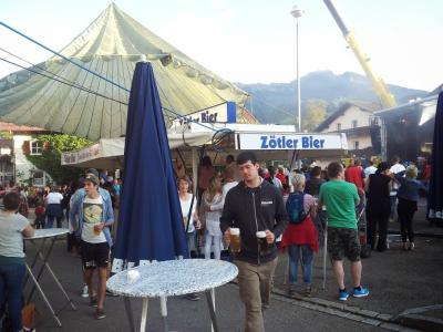
140802 Nesselwang Marktfest
neill, 15:48h
Last night was the annual Marktfest in Nesselwang
A video I took at midnight is at https://plus.google.com/u/0/photos/103827427036815679772/albums/6035783557911106593/6043304149483009730?pid=6043304149483009730&oid=103827427036815679772
A video I took at midnight is at https://plus.google.com/u/0/photos/103827427036815679772/albums/6035783557911106593/6043304149483009730?pid=6043304149483009730&oid=103827427036815679772
... link (0 Kommentare) ... comment
Freitag, 1. August 2014
140731 Seeg
neill, 20:20h
A fantastic route worked out by Wera. Through spectacular Allgäu scenery. We finished with a swim in the Kögelweiher.
41km and 680 meters of climbing
Track at http://www.gpsies.com/map.do?fileId=uapcfqmirlwlqhrt
Photos at https://plus.google.com/u/0/photos/103827427036815679772/albums/6030336146678088705
41km and 680 meters of climbing
Track at http://www.gpsies.com/map.do?fileId=uapcfqmirlwlqhrt
Photos at https://plus.google.com/u/0/photos/103827427036815679772/albums/6030336146678088705
... link (0 Kommentare) ... comment
... older stories