
... newer stories
Freitag, 7. August 2015
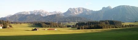
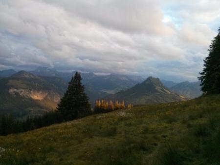
150806 Attlesee
neill, 22:22h
Thursday evening and very hot so the general consensus was "swimming" but we managed a bit of cycling first.

25km and 400 meters of climbing. Track is at http://www.gpsies.com/map.do?fileId=mvudxfdzdsoelxck
25km and 400 meters of climbing. Track is at http://www.gpsies.com/map.do?fileId=mvudxfdzdsoelxck
... link (0 Kommentare) ... comment
Mittwoch, 5. August 2015
150805 Hopferau
neill, 23:54h
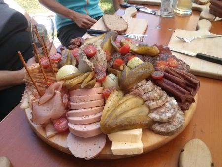
Yesterday we missed the Tuesday cycling so today Heidi and I went Wednesday cycling. We did not have long so it was a short race bike tour.
30km with 488 meters of climbing http://www.gpsies.com/map.do?fileId=wmkqwyznktvfbdlu
Photos in https://photos.google.com/album/AF1QipM6WdaUJLQzcPpcXD1XhdJOuLcFvWqg6YWLdfDJ
30km with 488 meters of climbing http://www.gpsies.com/map.do?fileId=wmkqwyznktvfbdlu
Photos in https://photos.google.com/album/AF1QipM6WdaUJLQzcPpcXD1XhdJOuLcFvWqg6YWLdfDJ
... link (0 Kommentare) ... comment
Samstag, 1. August 2015
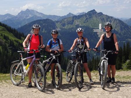
150801 Hölleritzeralpe
neill, 15:02h
Inge had a great tour planned from Günzesried-Säge through to Balderschwang and back through Austria.
About half way up the first climb it started to rain and by the time we reached the Hölleritzeralpe we were getting wet and the clouds were coming down to envelope us.

Decided to save the tour for another day and turned round and went home. Good decision!
13 km with 560 meters of climbing http://www.gpsies.com/map.do?fileId=lspopleqsaasqizu
About half way up the first climb it started to rain and by the time we reached the Hölleritzeralpe we were getting wet and the clouds were coming down to envelope us.
Decided to save the tour for another day and turned round and went home. Good decision!
13 km with 560 meters of climbing http://www.gpsies.com/map.do?fileId=lspopleqsaasqizu
... link (0 Kommentare) ... comment
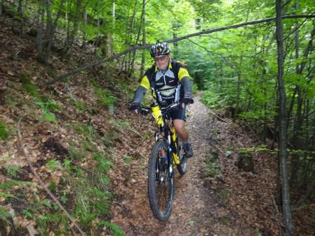
150730 Jungholz
neill, 15:00h
Karin chose tonights "Thursday Evening" tour. Past the Untere Reuttewanne Alpe and through to Jungholz and then down Vilstal and back through Pfronten.

32km with 625 meters of climbing. http://www.gpsies.com/map.do?fileId=cmehbfemsfjudqxb
32km with 625 meters of climbing. http://www.gpsies.com/map.do?fileId=cmehbfemsfjudqxb
... link (0 Kommentare) ... comment
Sonntag, 26. Juli 2015
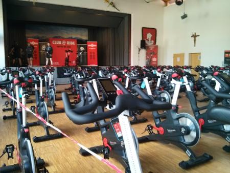
150725 Club Ride
neill, 12:15h
Five hours of spinning in Seeg.
... link (0 Kommentare) ... comment
Mittwoch, 22. Juli 2015
150721 Joch Pass
neill, 17:46h
Tuesday evening so Heidi, Jon and I were out race biking. Cycled to Wertach and then on through the Königsstrasse to Sonthofen.
From Sonthofen we returned via the Jochpass.
And the swimming in the Grüntensee.
64km and 952 meters of climbing. Track is at http://www.gpsies.com/map.do?fileId=cpcnaalzfmiffaud
From Sonthofen we returned via the Jochpass.
And the swimming in the Grüntensee.
64km and 952 meters of climbing. Track is at http://www.gpsies.com/map.do?fileId=cpcnaalzfmiffaud
... link (0 Kommentare) ... comment
Sonntag, 19. Juli 2015
150719 Roßbergalpe
neill, 20:06h
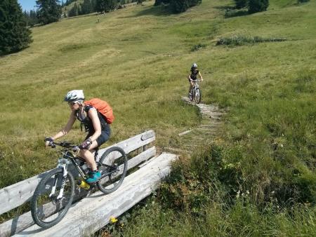
Today the "footballers" went mountain biking up to the Roßbergalpe and were kind enough to invite me.
We cycled straight there and then ate and drank too much before cycling back via the Dreiangelhütte and Untere Bichler Alpe.
49km and 993 meters of climbing. Track is at http://www.gpsies.com/map.do?fileId=mmvopdmerdilzceh

Photos at https://photos.google.com/album/AF1QipM6WdaUJLQzcPpcXD1XhdJOuLcFvWqg6YWLdfDJ
We cycled straight there and then ate and drank too much before cycling back via the Dreiangelhütte and Untere Bichler Alpe.
49km and 993 meters of climbing. Track is at http://www.gpsies.com/map.do?fileId=mmvopdmerdilzceh
Photos at https://photos.google.com/album/AF1QipM6WdaUJLQzcPpcXD1XhdJOuLcFvWqg6YWLdfDJ
... link (0 Kommentare) ... comment
Samstag, 18. Juli 2015
150718 Mittlere Stuibenalpe
neill, 18:15h
Inge planned a tour to the Alp via the Pfrontener Hütte.
Six ladies (Caro, Hätti, Heidi, Inge, Karin & Moni) and me took part. The weather was kind to us - not too hot and not too much rain.
60kms and 1500 meters of climbing in four and a half hours. Track is at http://www.gpsies.com/map.do?fileId=mxrkaqrwxtgmgvpe The route has a "ClimbByBike Index" of 73.36!
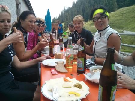
Photos at https://photos.google.com/album/AF1QipM6WdaUJLQzcPpcXD1XhdJOuLcFvWqg6YWLdfDJ
Six ladies (Caro, Hätti, Heidi, Inge, Karin & Moni) and me took part. The weather was kind to us - not too hot and not too much rain.
60kms and 1500 meters of climbing in four and a half hours. Track is at http://www.gpsies.com/map.do?fileId=mxrkaqrwxtgmgvpe The route has a "ClimbByBike Index" of 73.36!
Photos at https://photos.google.com/album/AF1QipM6WdaUJLQzcPpcXD1XhdJOuLcFvWqg6YWLdfDJ
... link (0 Kommentare) ... comment
Mittwoch, 15. Juli 2015
150714 Jungholz
neill, 23:12h
Gremml, Heidi and I out to climb lots of steep stuff (up to 21%), ride great trails and have fun.
36km and 1004 meters of climbing.
Track is at http://www.gpsies.com/map.do?fileId=xvsxybofvpvqdnqd
36km and 1004 meters of climbing.
Track is at http://www.gpsies.com/map.do?fileId=xvsxybofvpvqdnqd
... link (0 Kommentare) ... comment
Montag, 13. Juli 2015
150712 Breitenberg
neill, 00:02h
At 09:15 I received an invitation from Karin to be at the sports hall in an hour to cycle the Breitenberg.
There wer five of us. I was the token man. Hopsing later joined us at the Alm where we stopped for lunch.
On the way down Marion slipped on a curve. Lots of blood but hopefully no serious damage.
42 km with 1100 meters of climbing. Track is at http://www.gpsies.com/map.do?fileId=wbknsvanmaebdgrn
Pictures at https://photos.google.com/album/AF1QipM6WdaUJLQzcPpcXD1XhdJOuLcFvWqg6YWLdfDJ
... link (0 Kommentare) ... comment
Sonntag, 12. Juli 2015
150711 Schwarzenberg
neill, 00:17h
Heidi had an hour and a half off so we went for a quick race bike ride.
29 km and 430 meters of climbing. Track is at http://www.gpsies.com/map.do?fileId=wkcwpskvomqnxrmw
29 km and 430 meters of climbing. Track is at http://www.gpsies.com/map.do?fileId=wkcwpskvomqnxrmw
... link (0 Kommentare) ... comment
150711 Ruhbach
neill, 16:38h
Out on my own enjoying the mountains and valleys near Balderschwang.

From Balderschwang I headed towards the Riedbergerpass and then south past the Toniskopf Alpe. Trail down to Rohmoos was steep and washed out so I fell off at one point but luckily no one saw me.
Along the Starlach valley and then across the European watershed and on down the Ruhbach valley. Back to Balderschwang across the Sättele Pass.

Stopped at the Fuchs Alpe for lunch. The last hut in Germany in the middle of nowhere but free fast Internet thanks to our company. My colleague mounted an antenna in a tree and it works perfectly.
As I was sat at the Alpe 10 mountainbikers turned up who had watched me ride down the top of the pass. Their comments were "Respect, Crazy, Impressive and Suicidal" :-)
The tour until the Fuchs Alpe took just under three hours. After lunch back down to the village and car.
31 km with 975 meters of climbing. http://www.gpsies.com/map.do?fileId=clymioliwwmvjjft
Pictures at https://photos.google.com/album/AF1QipM6WdaUJLQzcPpcXD1XhdJOuLcFvWqg6YWLdfDJ
From Balderschwang I headed towards the Riedbergerpass and then south past the Toniskopf Alpe. Trail down to Rohmoos was steep and washed out so I fell off at one point but luckily no one saw me.
Along the Starlach valley and then across the European watershed and on down the Ruhbach valley. Back to Balderschwang across the Sättele Pass.
Stopped at the Fuchs Alpe for lunch. The last hut in Germany in the middle of nowhere but free fast Internet thanks to our company. My colleague mounted an antenna in a tree and it works perfectly.
As I was sat at the Alpe 10 mountainbikers turned up who had watched me ride down the top of the pass. Their comments were "Respect, Crazy, Impressive and Suicidal" :-)
The tour until the Fuchs Alpe took just under three hours. After lunch back down to the village and car.
31 km with 975 meters of climbing. http://www.gpsies.com/map.do?fileId=clymioliwwmvjjft
Pictures at https://photos.google.com/album/AF1QipM6WdaUJLQzcPpcXD1XhdJOuLcFvWqg6YWLdfDJ
... link (2 Kommentare) ... comment
Freitag, 10. Juli 2015
150709 Senkele
neill, 21:25h
A ride through Allgäu with two great trails.
My GPS once again only saved part of the track. This is getting annoying. But luckily Wera was along so I got the track from her.
37 kilometers and 650 meters of climbing.Track is at http://www.gpsies.com/map.do?fileId=iimxyowqpakzjmfs
My GPS once again only saved part of the track. This is getting annoying. But luckily Wera was along so I got the track from her.
37 kilometers and 650 meters of climbing.Track is at http://www.gpsies.com/map.do?fileId=iimxyowqpakzjmfs
... link (0 Kommentare) ... comment
Dienstag, 7. Juli 2015
150707 Grüntensee
neill, 23:28h
After so many days of abstinence I was looking forward to Tuesday cycling. But Heidi and Jon had appointments so I was out alone. Couldn't get motivated to do a huge tour so cycled round the Grüntensee.
20kms and 220 meters of climbing. Track is at http://www.gpsies.com/map.do?fileId=anjuvttywaxfvdvo
20kms and 220 meters of climbing. Track is at http://www.gpsies.com/map.do?fileId=anjuvttywaxfvdvo
... link (0 Kommentare) ... comment
Sonntag, 28. Juni 2015
150625 Schnitzlertal Trail
neill, 17:20h
A great ride planned by Wera. Up to the Schnitzlertal via Bichel in Wertach and then down a long long trail. Fun!
32 kms with 800 meters of clmbing.
My GPS only kept half the track so here is a link to Jon's data
http://www.gpsies.com/map.do?fileId=ulmbqwwticrlzsri
Photos are at https://photos.google.com/album/AF1QipNv1rMqVebUDOGzhnPcKFiq4lEpul7V6AzE_1to
32 kms with 800 meters of clmbing.
My GPS only kept half the track so here is a link to Jon's data
http://www.gpsies.com/map.do?fileId=ulmbqwwticrlzsri
Photos are at https://photos.google.com/album/AF1QipNv1rMqVebUDOGzhnPcKFiq4lEpul7V6AzE_1to
... link (0 Kommentare) ... comment
Mittwoch, 24. Juni 2015
150623 Dinserhütte
neill, 00:29h
Jon wanted to cycle up the Alpspitz so we did.
And then down towards Kappel and then back up to the back of the Edelsberg and then along a great (but very slippy) trail to Stuibental and then home. :-)
Gremml, Jon, Heidi and I. A fantastic tour!
25km with 1040 meters of climbing and some steep up and back down. Track is at http://www.gpsies.com/map.do?fileId=glhbysgmwyiibmsu
Pictures are at https://photos.google.com/album/AF1QipNv1rMqVebUDOGzhnPcKFiq4lEpul7V6AzE_1to
... link (1 Kommentar) ... comment
... older stories