
... newer stories
Sonntag, 19. Juni 2016
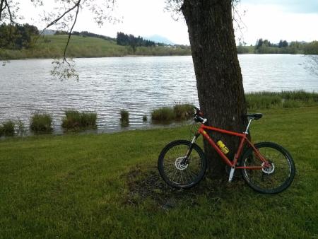
160619 Kronenhütte
neill, 23:29h
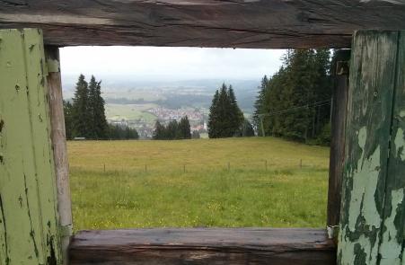
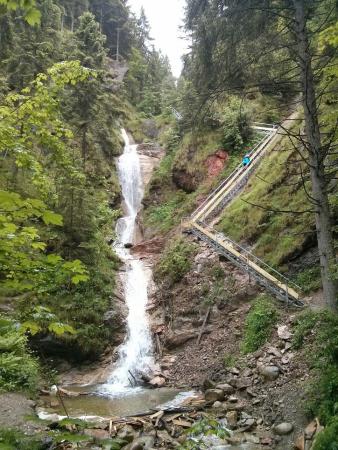
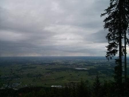
I am not a fan of "hiking"; I would much rather be out on one of my bikes. But today it rained all day and I really didn't want to get soaked from the rain and spray off the road again. It was too slippy for a race bike and too dirty for a MTB so I went for a walk up past the Nesselwang Waterfall and past the Kronenhütte.
Track is at http://www.gpsies.com/map.do?fileId=sgumvrmuxicjnbsh
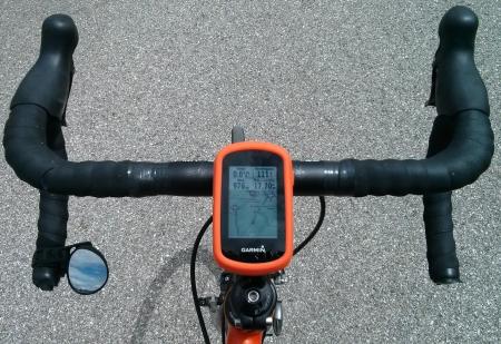
I was using my Garmin pulse band to measure my pulse. All the information was in my GPS and all appeared to be transferred to my mobile phone but there were no calories and no elevation gained shown. Asked for an explanation at https://forums.garmin.com/showthread.php?354302-Garmin-Connect-showing-0-calories
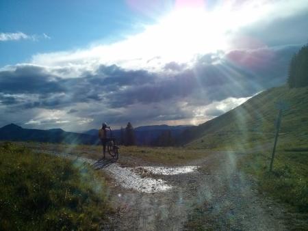
Photos at https://goo.gl/photos/g74VhzgtnUrDvxuRA
Track is at http://www.gpsies.com/map.do?fileId=sgumvrmuxicjnbsh
I was using my Garmin pulse band to measure my pulse. All the information was in my GPS and all appeared to be transferred to my mobile phone but there were no calories and no elevation gained shown. Asked for an explanation at https://forums.garmin.com/showthread.php?354302-Garmin-Connect-showing-0-calories
Photos at https://goo.gl/photos/g74VhzgtnUrDvxuRA
... link (0 Kommentare) ... comment
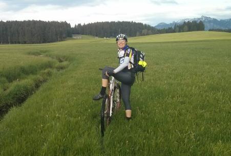
Samstag, 18. Juni 2016
160618 Grüntensee
neill, 15:24h
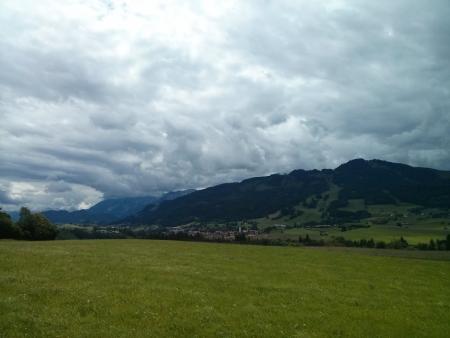
"Standard ride". Once round the Grüntensee. First race bike ride with my new Garmin pulse measurer.
After I had finished it suggested that I had used 492 calories. I did a very similar ride in 2014 (28.03.2014) using my Polar system and that suggested 686 calories so the Garmin system is obviously crediting me with far less calories.
Similarly I did the Reutewanne with my polar system on 17.09.2015 with my Polar system and was credited with 1563 calories and this week on 17.06.2016 with the Garmin system I only earned 716 calories.
One or both systems are lieing.
A calculator at http://www.mapmyride.com/improve/calorie_calculator/ calculated 3368kj for the Reuttewanne which is about 800 calories. For the ride round the Grüntensee it suggested 1042 calories!
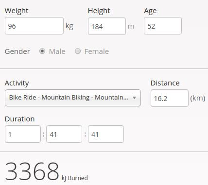
Another calculator at http://mtb-sauerland.bplaced.net/grevenstein/training/bergauf.htm says 858 calories for the Reuttewanne and 622 fpr the Grüntensee.
At the end of the day I am confused. It looks like "guess a number". But for the time being I'll believe Garmin as it is the easiest.
23km and 285 meters of climbing. Track is at http://www.gpsies.com/map.do?fileId=jkwhppzagstdpwir
After I had finished it suggested that I had used 492 calories. I did a very similar ride in 2014 (28.03.2014) using my Polar system and that suggested 686 calories so the Garmin system is obviously crediting me with far less calories.
Similarly I did the Reutewanne with my polar system on 17.09.2015 with my Polar system and was credited with 1563 calories and this week on 17.06.2016 with the Garmin system I only earned 716 calories.
One or both systems are lieing.
A calculator at http://www.mapmyride.com/improve/calorie_calculator/ calculated 3368kj for the Reuttewanne which is about 800 calories. For the ride round the Grüntensee it suggested 1042 calories!
Another calculator at http://mtb-sauerland.bplaced.net/grevenstein/training/bergauf.htm says 858 calories for the Reuttewanne and 622 fpr the Grüntensee.
At the end of the day I am confused. It looks like "guess a number". But for the time being I'll believe Garmin as it is the easiest.
23km and 285 meters of climbing. Track is at http://www.gpsies.com/map.do?fileId=jkwhppzagstdpwir
... link (0 Kommentare) ... comment
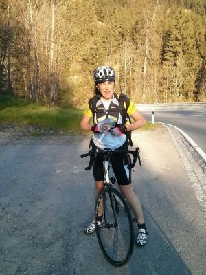
Freitag, 17. Juni 2016
160617 Reuttewanne Alpe
neill, 23:49h
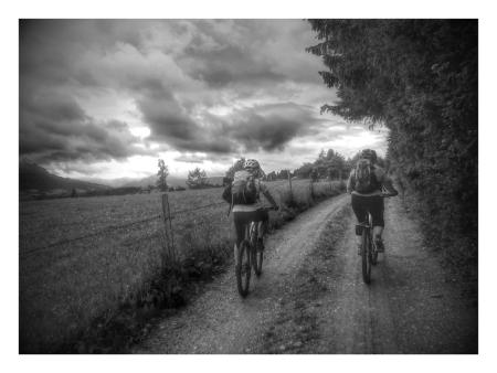
Despite the dark clouds, Caro and I cycled up the Reuttewanne and were rewarded with sunshine and a rainbow.
I was using my new pulse measuring belt that connects directly to my GPS. My GPS saves all the values and later synchronises them with Garmin Connect which then gives me all the information on my smartphone. Google Connect also shares the data with myfitnesspal which then knows how many calories I have used up exercising. Cool!
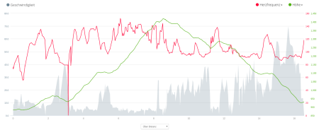
I used up over 700 Kcal cycling but in Alten Reichenbach I put 500 back.
15.5km and 647 meters of climbing. Track is at http://www.gpsies.com/map.do?fileId=wwpdvfchoohkepdq
Photos at https://goo.gl/photos/JYAG6B6TM26n8ogq6
I was using my new pulse measuring belt that connects directly to my GPS. My GPS saves all the values and later synchronises them with Garmin Connect which then gives me all the information on my smartphone. Google Connect also shares the data with myfitnesspal which then knows how many calories I have used up exercising. Cool!
I used up over 700 Kcal cycling but in Alten Reichenbach I put 500 back.
15.5km and 647 meters of climbing. Track is at http://www.gpsies.com/map.do?fileId=wwpdvfchoohkepdq
Photos at https://goo.gl/photos/JYAG6B6TM26n8ogq6
... link (0 Kommentare) ... comment
Donnerstag, 16. Juni 2016
160615 Sportheim Böck
neill, 00:24h
Left the village in sunshine and was sweating as we followed yesterdays route up the Alpspitz. By the time Caro and I reached the top it was pouring with rain and we arrived back in the valley soaked through.
No track as my GPS batteries ran out half way through the tour. But based on a similar ride: 12km and 600 meters of climbing.
No track as my GPS batteries ran out half way through the tour. But based on a similar ride: 12km and 600 meters of climbing.
... link (0 Kommentare) ... comment
Mittwoch, 15. Juni 2016
160614 Maria Trost (twice)
neill, 00:20h
Tuesday night but too cold and wet for Jon (he was dressed and ready to go but says leaving the house in a rain storm is not his thing). Wrapped up in waterproofs, we cycled up towards Maria Trost but once out of the trees it was windy, cold and very wet so we cycled back down and up again. This time by the time we left the trees it has stopped raining so we continued up to the start of the Engelbergweg.
We finished the evening with tea and Baileys.
10 kilometers and 500 meters of climbing. Track is at http://www.gpsies.com/map.do?fileId=xwwoeqzomgoqafec
We finished the evening with tea and Baileys.
10 kilometers and 500 meters of climbing. Track is at http://www.gpsies.com/map.do?fileId=xwwoeqzomgoqafec
... link (0 Kommentare) ... comment
Montag, 13. Juni 2016
160613 Ellegg
neill, 23:05h
Evening bike ride with Karin K. & Caro. We expected rain but were lucky.
Full size picture at https://goo.gl/photos/JYAG6B6TM26n8ogq6
27km and 495 meters of climbing. Track is at http://www.gpsies.com/map.do?fileId=vtwnmtyxrdwzpfle
Full size picture at https://goo.gl/photos/JYAG6B6TM26n8ogq6
27km and 495 meters of climbing. Track is at http://www.gpsies.com/map.do?fileId=vtwnmtyxrdwzpfle
... link (0 Kommentare) ... comment
Sonntag, 12. Juni 2016
160612 Hundelskopfhütte
neill, 21:20h
With Caro, Stefano & Karin K.
After a leisurely breakfast we enjoyed an overcast but dry Sunday. It only rained while we were in the hut eating lunch.
25 km and 860 meters of climbing. Track is at http://www.gpsies.com/map.do?fileId=tevdsbpljlojzjne
Pictures at https://goo.gl/photos/JYAG6B6TM26n8ogq6
After a leisurely breakfast we enjoyed an overcast but dry Sunday. It only rained while we were in the hut eating lunch.
25 km and 860 meters of climbing. Track is at http://www.gpsies.com/map.do?fileId=tevdsbpljlojzjne
Pictures at https://goo.gl/photos/JYAG6B6TM26n8ogq6
... link (0 Kommentare) ... comment
Freitag, 10. Juni 2016
160610 Grüntensee
neill, 22:49h
Sunny evening. Finished at work. No plans. So 1 hour on the race bike. Relaxing and fun!
23 km and 272 meters of climbing Track at http://www.gpsies.com/map.do?fileId=hyzegdcsdhsinzqw
23 km and 272 meters of climbing Track at http://www.gpsies.com/map.do?fileId=hyzegdcsdhsinzqw
... link (0 Kommentare) ... comment
Dienstag, 7. Juni 2016
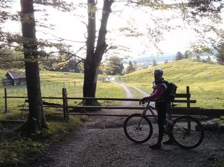
160607 Haslacher Alpe
neill, 23:02h
Just Jon and I this evening and Jon wanted to try mountain biking to see how he did after his accident last year. Obviously recovered - didn't fall off once :-)
22km und 476 meters of climbing. http://www.gpsies.com/map.do?fileId=tfneygmuyzgibbsk
22km und 476 meters of climbing. http://www.gpsies.com/map.do?fileId=tfneygmuyzgibbsk
... link (0 Kommentare) ... comment
Sonntag, 5. Juni 2016
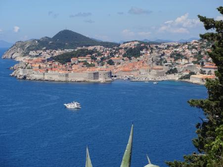
160525 Dubrovnik
neill, 17:32h
The "2016 Racing Bike Adventure".
Heidi and I cycled from Nesselwang to Dubrovnik.
1200 kilometers with 17131 meters of climbing. Nearly two times Everest! Six international border crossings and numerous passes. Lunch in mountain alps and dinner on the harbour wall.
The complete route is shown at http://www.gpsies.com/viewStages.do?fileId=jngvnsvdgwvloizs&fileId=aquwepttwsnmxwhj&fileId=uoniecwqhavacqng&fileId=xygsfrjfocuvfuoh&fileId=jsenzmzjgmgmsuta&fileId=lahyrimykudsfpnz&fileId=xqyrooayatuiqofx&fileId=heexcgqrueavqrzr&fileId=oqkljabdiqzndpmt&fileId=ifmoxjajgquzjzsy
Day 1 - Nesselwang to Innsbruck (Austria)
http://www.gpsies.com/map.do?fileId=jngvnsvdgwvloizs
Left at lunchtime to get over the Fernpass and positioned for the Brenner tomorrow. The run down the Fernpass was fast and fun as we had no cars in front of or behind us.
Day 2 - Innsbruck to Reischach (Italy)
http://www.gpsies.com/map.do?fileId=aquwepttwsnmxwhj
Across the Brenner Pass. We took three hours to the summit and cars were taking one and a half or more for the same stretch because of all the queues. On the Italian side we used cycle paths all the way.
Day 3 - Reischach to Villa Santina (Italy)
http://www.gpsies.com/map.do?fileId=uoniecwqhavacqng
Two passes and lots of beautiful scenery. After the second pass it was all downhill to the pizzeria where we spent the night.
Day 4 - Villa Santina to Spondnja Idrija (Slovenia)
http://www.gpsies.com/map.do?fileId=xygsfrjfocuvfuoh
A nice easy ride to warm up next to the river and then the crossing of a "really" steep pass. Near the start we met a shocked swiss biker on his way down who said "you are not really going to cycle up there are you?"
Ended the day in an empty valley with only one hotel. But that one was enough.
Day 5 - Spondnja Idrija to Rijeka (Croatia)
http://www.gpsies.com/map.do?fileId=jsenzmzjgmgmsuta
The last day "in the mountains". A collection of small passes took us to the sea. It started raining at the Croatian border and we reached Rijeka soaked through.
Day 6 - Rijeka to Rab (Croatia)
http://www.gpsies.com/map.do?fileId=lahyrimykudsfpnz
Hid from the morning rain in a bus shelter. Enjoyed the ride across the island of Krk and the ferry journey to the island of Rab. Hotel right on the harbour wall.
Day 7 - Rab to Skradin (Croatia)
http://www.gpsies.com/map.do?fileId=xqyrooayatuiqofx
Started the day with a water taxi trip to the island of Pag. First half of the day on the Island and second half in the war marked inland. Ruined, shot up houses still decaying 20 years later. Spent the night in the beautiful town of Skrada.
Day 8 - Skradin to Podstrana (Croatia)
http://www.gpsies.com/map.do?fileId=heexcgqrueavqrzr
Cycled to the coast and then visited Split which was definitely not worth the effort. On along the coast until "rain stopped play" and we took refuge in the next hotel
Day 9 - Podstrana to Neum (Bosnia i Hercegovina)
Fantastic Adriatic coastline. Spent the night in Bosnia.
http://www.gpsies.com/map.do?fileId=heexcgqrueavqrzr
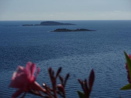
Day 10 - Neum to Dubrovnik (Croatia)
http://www.gpsies.com/map.do?fileId=ifmoxjajgquzjzsy
An easy day to our destination. In the evening we enjoyed aperitif, main course and sweet in three different restaurants.
Day 11 - Dubrovnik to Airport (Croatia)
http://www.gpsies.com/map.do?fileId=hgncxvxtmjiqavel
All day to do 20 kilometers so we added 8 kilometers with a kayak tour to the island of Supetar.
Some pictures at https://goo.gl/photos/gpMxUWAyBmVCWZFR8
Heidi and I cycled from Nesselwang to Dubrovnik.
1200 kilometers with 17131 meters of climbing. Nearly two times Everest! Six international border crossings and numerous passes. Lunch in mountain alps and dinner on the harbour wall.
The complete route is shown at http://www.gpsies.com/viewStages.do?fileId=jngvnsvdgwvloizs&fileId=aquwepttwsnmxwhj&fileId=uoniecwqhavacqng&fileId=xygsfrjfocuvfuoh&fileId=jsenzmzjgmgmsuta&fileId=lahyrimykudsfpnz&fileId=xqyrooayatuiqofx&fileId=heexcgqrueavqrzr&fileId=oqkljabdiqzndpmt&fileId=ifmoxjajgquzjzsy
Day 1 - Nesselwang to Innsbruck (Austria)
http://www.gpsies.com/map.do?fileId=jngvnsvdgwvloizs
Left at lunchtime to get over the Fernpass and positioned for the Brenner tomorrow. The run down the Fernpass was fast and fun as we had no cars in front of or behind us.
Day 2 - Innsbruck to Reischach (Italy)
http://www.gpsies.com/map.do?fileId=aquwepttwsnmxwhj
Across the Brenner Pass. We took three hours to the summit and cars were taking one and a half or more for the same stretch because of all the queues. On the Italian side we used cycle paths all the way.
Day 3 - Reischach to Villa Santina (Italy)
http://www.gpsies.com/map.do?fileId=uoniecwqhavacqng
Two passes and lots of beautiful scenery. After the second pass it was all downhill to the pizzeria where we spent the night.
Day 4 - Villa Santina to Spondnja Idrija (Slovenia)
http://www.gpsies.com/map.do?fileId=xygsfrjfocuvfuoh
A nice easy ride to warm up next to the river and then the crossing of a "really" steep pass. Near the start we met a shocked swiss biker on his way down who said "you are not really going to cycle up there are you?"
Ended the day in an empty valley with only one hotel. But that one was enough.
Day 5 - Spondnja Idrija to Rijeka (Croatia)
http://www.gpsies.com/map.do?fileId=jsenzmzjgmgmsuta
The last day "in the mountains". A collection of small passes took us to the sea. It started raining at the Croatian border and we reached Rijeka soaked through.
Day 6 - Rijeka to Rab (Croatia)
http://www.gpsies.com/map.do?fileId=lahyrimykudsfpnz
Hid from the morning rain in a bus shelter. Enjoyed the ride across the island of Krk and the ferry journey to the island of Rab. Hotel right on the harbour wall.
Day 7 - Rab to Skradin (Croatia)
http://www.gpsies.com/map.do?fileId=xqyrooayatuiqofx
Started the day with a water taxi trip to the island of Pag. First half of the day on the Island and second half in the war marked inland. Ruined, shot up houses still decaying 20 years later. Spent the night in the beautiful town of Skrada.
Day 8 - Skradin to Podstrana (Croatia)
http://www.gpsies.com/map.do?fileId=heexcgqrueavqrzr
Cycled to the coast and then visited Split which was definitely not worth the effort. On along the coast until "rain stopped play" and we took refuge in the next hotel
Day 9 - Podstrana to Neum (Bosnia i Hercegovina)
Fantastic Adriatic coastline. Spent the night in Bosnia.
http://www.gpsies.com/map.do?fileId=heexcgqrueavqrzr
Day 10 - Neum to Dubrovnik (Croatia)
http://www.gpsies.com/map.do?fileId=ifmoxjajgquzjzsy
An easy day to our destination. In the evening we enjoyed aperitif, main course and sweet in three different restaurants.
Day 11 - Dubrovnik to Airport (Croatia)
http://www.gpsies.com/map.do?fileId=hgncxvxtmjiqavel
All day to do 20 kilometers so we added 8 kilometers with a kayak tour to the island of Supetar.
Some pictures at https://goo.gl/photos/gpMxUWAyBmVCWZFR8
... link (0 Kommentare) ... comment
Freitag, 20. Mai 2016
160519 Pfeiferberg
neill, 22:36h
Cold and wet on a Thursday night so, predictably, the cycle group was Wera, Heidi and I. We cycled up to the Obere Reuttewanne Alp via the quarry and then back down to Stuibental through the Pfeiferberg.
Luckily we were all well wrapped up.
20kms with 667 meters of climbingTrack is at http://www.gpsies.com/map.do?fileId=sghgudrglzjkgcim
More pictures at https://goo.gl/photos/jD4tuQEbUgCWmLDG9
Luckily we were all well wrapped up.
20kms with 667 meters of climbingTrack is at http://www.gpsies.com/map.do?fileId=sghgudrglzjkgcim
More pictures at https://goo.gl/photos/jD4tuQEbUgCWmLDG9
... link (0 Kommentare) ... comment
Mittwoch, 18. Mai 2016
160517 Falkenstein
neill, 00:31h
Jon was still recovering from Egypt so Heidi and I cycled to the Falkenstein and back down through Benken.
28km and 592 meters of climbing. Track at http://www.gpsies.com/map.do?fileId=whxakfsvggdtqbxb
28km and 592 meters of climbing. Track at http://www.gpsies.com/map.do?fileId=whxakfsvggdtqbxb
... link (0 Kommentare) ... comment
Sonntag, 15. Mai 2016
160515 Ellegg
neill, 21:36h
It is awful weather but Caro convinced me that cycling in 10°C and rain & hail is fun so we cycled over the Ellegg and back via Haag. Going up hill was bearable but downhill it was ski gloves an 4 layers of clothes.
Still better than an afternoon sat at home.
33km and 730 meters of climbing. Track is at http://www.gpsies.com/map.do?fileId=xfjxfwntvvgpyajb
More photos at https://goo.gl/photos/jD4tuQEbUgCWmLDG9
Still better than an afternoon sat at home.
33km and 730 meters of climbing. Track is at http://www.gpsies.com/map.do?fileId=xfjxfwntvvgpyajb
More photos at https://goo.gl/photos/jD4tuQEbUgCWmLDG9
... link (0 Kommentare) ... comment
160510 Eisenberg
neill, 21:35h
I had visitors but we still managed to sneak off for a few hours with the mountain bikes. Without a plan we cycled where ever fancy took us and up over the Eisenberg.
27km and 464 meters of climbing. Track is at http://www.gpsies.com/map.do?fileId=istijhcdxvrrhjtc
More photos at https://goo.gl/photos/jD4tuQEbUgCWmLDG9
27km and 464 meters of climbing. Track is at http://www.gpsies.com/map.do?fileId=istijhcdxvrrhjtc
More photos at https://goo.gl/photos/jD4tuQEbUgCWmLDG9
... link (0 Kommentare) ... comment
Samstag, 7. Mai 2016
160506 Jochpass
neill, 11:35h
Friday evening bike ride with Heidi. Through the "Königsstrasse" to Sonthofen and then back over the Jochpass. Heidi's first time out this week so she was feeling very fit. We averaged 9.5kmh UP the Jochpass.
59 km with 1021 meters of climbing. Track is at http://www.gpsies.com/map.do?fileId=glbprogjbfykldbs
59 km with 1021 meters of climbing. Track is at http://www.gpsies.com/map.do?fileId=glbprogjbfykldbs
... link (0 Kommentare) ... comment
... older stories