
... newer stories
Dienstag, 5. Juli 2016
160705 Tannheimertal
neill, 23:59h
Tuesday evening but Heidi had "Krabbelgruppe" :-(
And Jon had friends round :-(
So I was out on my own.
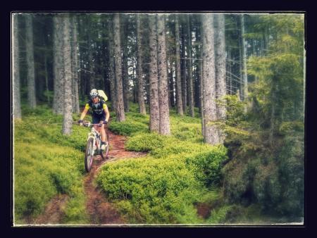
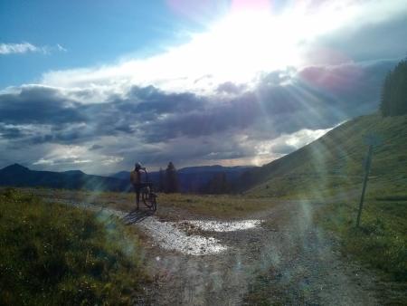
Did the Tannheimertal route with my race bike.
48.5 km with 565 meters of climbing. And all in 2:03! Track is at http://www.gpsies.com/map.do?fileId=xngdrurnpgedhwff
Afterwards I decided I had earned an ice cream and at the ice cafe I met Marion and Robert and then Caro so we enjoyed a hot amaretto with cream.
And Jon had friends round :-(
So I was out on my own.
Did the Tannheimertal route with my race bike.
48.5 km with 565 meters of climbing. And all in 2:03! Track is at http://www.gpsies.com/map.do?fileId=xngdrurnpgedhwff
Afterwards I decided I had earned an ice cream and at the ice cafe I met Marion and Robert and then Caro so we enjoyed a hot amaretto with cream.
... link (0 Kommentare) ... comment
Montag, 4. Juli 2016
160704 Sportheim Böck
neill, 21:41h
After work and the sun was shining. Needed to "earn" some calories to be able to enjoy a few slices of pizza :-)
Up to Sportheim Böck and then back down past the Kappeller Alp. Just looking at my heartbeat shows which part of the trip was uphill. An average of over 130 uphill and under 100 downhill and flat.
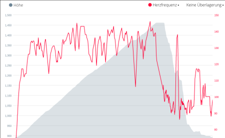
14 km and 605 meters of climbing.Track is at http://www.gpsies.com/map.do?fileId=jfenqayykwlhpahh
Up to Sportheim Böck and then back down past the Kappeller Alp. Just looking at my heartbeat shows which part of the trip was uphill. An average of over 130 uphill and under 100 downhill and flat.
14 km and 605 meters of climbing.Track is at http://www.gpsies.com/map.do?fileId=jfenqayykwlhpahh
... link (0 Kommentare) ... comment
Sonntag, 3. Juli 2016
160703 Forggensee
neill, 23:00h
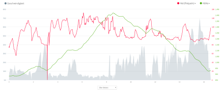
An afternoon sailing with Chris & Philipp. Three hours with a Dyas (http://www.dyas.org/wp/daten/)
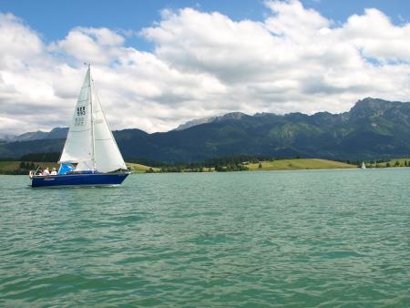
As the following diagram shows the wind was about 10km/h (5-6 knots) but there were a lot of lulls.
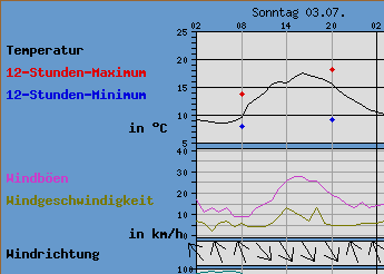
7 nautical miles in total. Our track is at http://www.gpsies.com/map.do?fileId=otoqgbfbtubirxom
Original photo at https://goo.gl/photos/qdM9peYJsuZzbJLZ6 (thanks Chris)
As the following diagram shows the wind was about 10km/h (5-6 knots) but there were a lot of lulls.
7 nautical miles in total. Our track is at http://www.gpsies.com/map.do?fileId=otoqgbfbtubirxom
Original photo at https://goo.gl/photos/qdM9peYJsuZzbJLZ6 (thanks Chris)
... link (0 Kommentare) ... comment
Samstag, 2. Juli 2016
160702 Frauensee
neill, 18:50h
A tour planned by Inge. Out to the Frauensee and back. The original plan was a bit longer but it rained and was generally looking like we were going to get very wet.
On the way back we stopped at the Falkenstein Restaurant in Pfronten.
65km and 780 meters of climbing. Track is at http://www.gpsies.com/map.do?fileId=gfwuxyukbrymdajd
Pictures at https://goo.gl/photos/JYAG6B6TM26n8ogq6
Inges pictures at https://www.google.com/url?hl=en-GB&q=https://picasaweb.google.com/lh/sredir?uname%3DSpyderwomanTV%26target%3DALBUM%26id%3D6303217317790472705%26authkey%3DGv1sRgCOuC0_jdpbjQDg%26invite%3DCK7mx5oE%26feat%3Demail&source=gmail&ust=1467695183122000&usg=AFQjCNHX1IFIY_JA2xvcCcopFA9IJ4DeFA
... link (0 Kommentare) ... comment
160630 Moorgang
neill, 18:49h
Wera was in the Dolomites with Heidi. Jon was away. The rest of Group 2 wanted a flat tour so Bettina and I joined Group 1 for a dirty ride through the Moorgang. On the way home we got absolutely soaked.
25km and 490 meters of climbing. Track is at http://www.gpsies.com/map.do?fileId=ncwnelvuncawshpm
Pictures at https://goo.gl/photos/JYAG6B6TM26n8ogq6
25km and 490 meters of climbing. Track is at http://www.gpsies.com/map.do?fileId=ncwnelvuncawshpm
Pictures at https://goo.gl/photos/JYAG6B6TM26n8ogq6
... link (0 Kommentare) ... comment
160629 Maria Trost
neill, 18:47h
Left home on my mountain bike. Got about 10 meters and received messages about problems in our network so turned round and went and sorted that out. Set off again and reached part way up to Maria Trost before the next message arrived. Turned round again. After that I decided to take a hot showera nd something to eat.
4km with 177 meters of climbing (probably my shortest bike ride this year) Track is at http://www.gpsies.com/map.do?fileId=ytqjlnlejhqwange
4km with 177 meters of climbing (probably my shortest bike ride this year) Track is at http://www.gpsies.com/map.do?fileId=ytqjlnlejhqwange
... link (0 Kommentare) ... comment
160628 Durach
neill, 18:44h
By the time I finished at work (meeting in Isny) Heidi was already out on her race bike but I cycled to meet her and thus managed a short trip to Durach and back.
42km with 540 meters of climbing. Track is at http://www.gpsies.com/map.do?fileId=asfojizlsuzulamw
42km with 540 meters of climbing. Track is at http://www.gpsies.com/map.do?fileId=asfojizlsuzulamw
... link (0 Kommentare) ... comment
160627 Grüntensee
neill, 18:43h
A quick after work trip round the Grüntensee with my race bike and Heidi.
20.6km with 242 meters of climbing. Track is at http://www.gpsies.com/map.do?fileId=wzizgpgexivjpfud
20.6km with 242 meters of climbing. Track is at http://www.gpsies.com/map.do?fileId=wzizgpgexivjpfud
... link (0 Kommentare) ... comment
Montag, 27. Juni 2016
160625 Grüntensee
neill, 17:41h
The weather forecast promised rainfall of biblical proportions in the afternoon so I went for a ride in the morning.
They were correct about the weather. It was like watching a river fall out of the sky.
22km with 283 meters of climbing. Track is at http://www.gpsies.com/map.do?fileId=pqubwdoztfvtbmhy
They were correct about the weather. It was like watching a river fall out of the sky.
22km with 283 meters of climbing. Track is at http://www.gpsies.com/map.do?fileId=pqubwdoztfvtbmhy
... link (0 Kommentare) ... comment
Freitag, 24. Juni 2016
160623 Bärenmoosalpe
neill, 09:15h
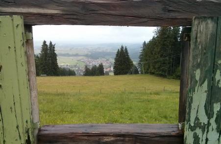
Thursday evening and the sun was shining. Wera had planned to cycle to the Bärenmoos so we split in to the "mountaineers" and the "flat landers".
A beer at the Bärenmoos tasted fantastic. Afterwards we did the Milchhäusle trail.
36km and 796 meters of climbing. Track is at http://www.gpsies.com/map.do?fileId=cjzxqimnkxphofzn
A beer at the Bärenmoos tasted fantastic. Afterwards we did the Milchhäusle trail.
36km and 796 meters of climbing. Track is at http://www.gpsies.com/map.do?fileId=cjzxqimnkxphofzn
... link (0 Kommentare) ... comment
Donnerstag, 23. Juni 2016
160622 Wertach
neill, 09:27h
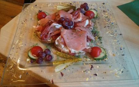
This evening we had to go to a meeting in Wertach so we cycled there and back with the race bikes. We were late setting off so the trip there was very fast. on the way back we took things a little more leisurely.
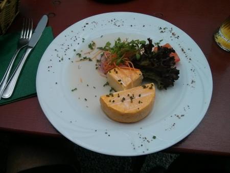
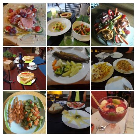
There was some food there so this seems like a good point to add a collage of a few recent "cycling meals"
Original is at https://goo.gl/photos/wqf6vrzCTFbhv5HeA
There was some food there so this seems like a good point to add a collage of a few recent "cycling meals"
Original is at https://goo.gl/photos/wqf6vrzCTFbhv5HeA
... link (0 Kommentare) ... comment
Mittwoch, 22. Juni 2016
160621 Edelsberg
neill, 09:12h
Tuesday night. jon decided to watch Germany playing football but Gremml took his place. It was drizzling but luckily we had decided on Mountain bikes.
Up to the Edelsberg past Maria Trost and then all the way back down on wet (and therefore challenging) trails. Brilliant fun.
Afterwards a bite to eat and a few drinks at Wera and Gremml's. :-)
22.5 km and 842 meters of climbing. Track is at http://www.gpsies.com/map.do?fileId=nhoabdtonjxmxkjp
Photos at https://goo.gl/photos/JYAG6B6TM26n8ogq6
... link (0 Kommentare) ... comment
Dienstag, 21. Juni 2016
160620 Sorg
neill, 00:04h
Caro, Stefano and Karin K.after work tour. Vilstal and Rehbach to the Sorg Alpe. Brotzeit! Home past the Stuibental Alpe.
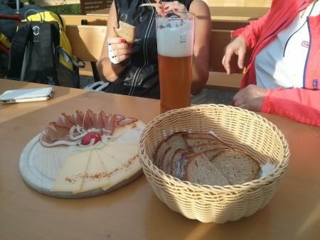
35km and 816 meters of climbing. Track is at http://www.gpsies.com/map.do?fileId=jyrpywtsixzwxfaz
35km and 816 meters of climbing. Track is at http://www.gpsies.com/map.do?fileId=jyrpywtsixzwxfaz
... link (0 Kommentare) ... comment
Sonntag, 19. Juni 2016
160619 Kronenhütte
neill, 23:29h
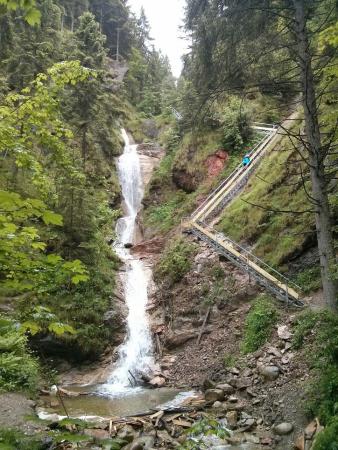
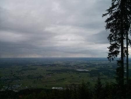
I am not a fan of "hiking"; I would much rather be out on one of my bikes. But today it rained all day and I really didn't want to get soaked from the rain and spray off the road again. It was too slippy for a race bike and too dirty for a MTB so I went for a walk up past the Nesselwang Waterfall and past the Kronenhütte.
Track is at http://www.gpsies.com/map.do?fileId=sgumvrmuxicjnbsh
I was using my Garmin pulse band to measure my pulse. All the information was in my GPS and all appeared to be transferred to my mobile phone but there were no calories and no elevation gained shown. Asked for an explanation at https://forums.garmin.com/showthread.php?354302-Garmin-Connect-showing-0-calories
Photos at https://goo.gl/photos/g74VhzgtnUrDvxuRA
... link (0 Kommentare) ... comment
Samstag, 18. Juni 2016
160618 Grüntensee
neill, 15:24h
"Standard ride". Once round the Grüntensee. First race bike ride with my new Garmin pulse measurer.
After I had finished it suggested that I had used 492 calories. I did a very similar ride in 2014 (28.03.2014) using my Polar system and that suggested 686 calories so the Garmin system is obviously crediting me with far less calories.
Similarly I did the Reutewanne with my polar system on 17.09.2015 with my Polar system and was credited with 1563 calories and this week on 17.06.2016 with the Garmin system I only earned 716 calories.
One or both systems are lieing.
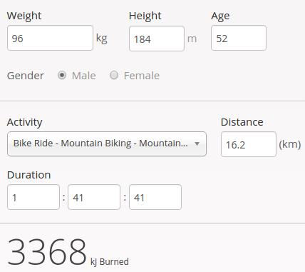
A calculator at http://www.mapmyride.com/improve/calorie_calculator/ calculated 3368kj for the Reuttewanne which is about 800 calories. For the ride round the Grüntensee it suggested 1042 calories!
Another calculator at http://mtb-sauerland.bplaced.net/grevenstein/training/bergauf.htm says 858 calories for the Reuttewanne and 622 fpr the Grüntensee.
At the end of the day I am confused. It looks like "guess a number". But for the time being I'll believe Garmin as it is the easiest.
23km and 285 meters of climbing. Track is at http://www.gpsies.com/map.do?fileId=jkwhppzagstdpwir
After I had finished it suggested that I had used 492 calories. I did a very similar ride in 2014 (28.03.2014) using my Polar system and that suggested 686 calories so the Garmin system is obviously crediting me with far less calories.
Similarly I did the Reutewanne with my polar system on 17.09.2015 with my Polar system and was credited with 1563 calories and this week on 17.06.2016 with the Garmin system I only earned 716 calories.
One or both systems are lieing.
A calculator at http://www.mapmyride.com/improve/calorie_calculator/ calculated 3368kj for the Reuttewanne which is about 800 calories. For the ride round the Grüntensee it suggested 1042 calories!
Another calculator at http://mtb-sauerland.bplaced.net/grevenstein/training/bergauf.htm says 858 calories for the Reuttewanne and 622 fpr the Grüntensee.
At the end of the day I am confused. It looks like "guess a number". But for the time being I'll believe Garmin as it is the easiest.
23km and 285 meters of climbing. Track is at http://www.gpsies.com/map.do?fileId=jkwhppzagstdpwir
... link (0 Kommentare) ... comment
Freitag, 17. Juni 2016
160617 Reuttewanne Alpe
neill, 23:49h
Despite the dark clouds, Caro and I cycled up the Reuttewanne and were rewarded with sunshine and a rainbow.
I was using my new pulse measuring belt that connects directly to my GPS. My GPS saves all the values and later synchronises them with Garmin Connect which then gives me all the information on my smartphone. Google Connect also shares the data with myfitnesspal which then knows how many calories I have used up exercising. Cool!
I used up over 700 Kcal cycling but in Alten Reichenbach I put 500 back.
15.5km and 647 meters of climbing. Track is at http://www.gpsies.com/map.do?fileId=wwpdvfchoohkepdq
Photos at https://goo.gl/photos/JYAG6B6TM26n8ogq6
... link (0 Kommentare) ... comment
Donnerstag, 16. Juni 2016
160615 Sportheim Böck
neill, 00:24h
Left the village in sunshine and was sweating as we followed yesterdays route up the Alpspitz. By the time Caro and I reached the top it was pouring with rain and we arrived back in the valley soaked through.
No track as my GPS batteries ran out half way through the tour. But based on a similar ride: 12km and 600 meters of climbing.
No track as my GPS batteries ran out half way through the tour. But based on a similar ride: 12km and 600 meters of climbing.
... link (0 Kommentare) ... comment
Mittwoch, 15. Juni 2016
160614 Maria Trost (twice)
neill, 00:20h
Tuesday night but too cold and wet for Jon (he was dressed and ready to go but says leaving the house in a rain storm is not his thing). Wrapped up in waterproofs, we cycled up towards Maria Trost but once out of the trees it was windy, cold and very wet so we cycled back down and up again. This time by the time we left the trees it has stopped raining so we continued up to the start of the Engelbergweg.
We finished the evening with tea and Baileys.
10 kilometers and 500 meters of climbing. Track is at http://www.gpsies.com/map.do?fileId=xwwoeqzomgoqafec
We finished the evening with tea and Baileys.
10 kilometers and 500 meters of climbing. Track is at http://www.gpsies.com/map.do?fileId=xwwoeqzomgoqafec
... link (0 Kommentare) ... comment
... older stories